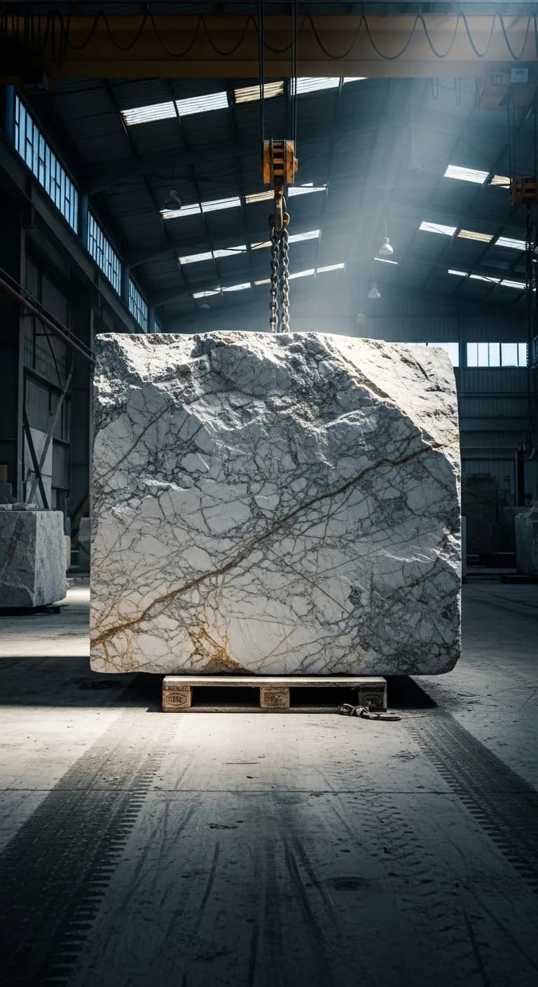
Every Block Gets a
Birth Certificate.
Digital. Permanent. Precise.
When a block is extracted from the quarry face, it is scanned with iPhone LiDAR. In 60 seconds, the system captures precise dimensions (+-2cm accuracy), GPS coordinates, quarry face position, extraction timestamp, and initial quality assessment.
This data follows the block forever -- through processing, inventory, allocation, shipping, and client delivery. It is the Digital Product Passport that the EU will require by 2027-2028. Companies building this data today will have 5 years of clean traceability when enforcement begins.
LiDAR precision. +-2cm accuracy. Complete traceability.
+-2cm
Accuracy
vs +-5cm manual
87%
Fewer Errors
3% to 0.4% error rate
60s
Per Block
vs 5 min manual
What a Digital Birth Certificate Contains
Every block scanned with Noria carries a permanent digital record. This is not a measurement note. It is a complete identity document that follows the block through its entire lifecycle -- from quarry face to client installation.
This data is the foundation of every downstream module. Spectral color matching reads the visual record. The Allocator evaluates the grade and dimensions. Logistics calculates weight from the volume. The Client Portal displays the photographs. One scan. Eleven modules informed.
MRB-X101
Calacatta Oro · Grade A
Your iPhone Is Now a Quarry Instrument.
Every competitor in the natural stone industry offers software. Noria offers hardware integration. The LiDAR sensor in an iPhone Pro -- the same sensor used in architectural surveying and industrial measurement -- captures block dimensions with +-2cm accuracy. No specialized equipment. No calibration. No EUR 15,000 laser scanner that breaks in quarry dust.
Your team already has iPhones. The Noria mobile app transforms them into precision measurement instruments that work in direct sunlight, in dust, in rain, and with zero cellular connectivity.
This is a moat. Software can be copied in six months. Hardware integration with proprietary scanning algorithms, offline-first architecture, and quarry-condition resilience takes years. No competitor in the natural stone space has this capability.
Accuracy
Manual: +-5cm
LiDAR: +-2cm
Error Rate
Manual: 3%
LiDAR: 0.4%
Time / Block
Manual: 5 min
LiDAR: 60s
Equipment Cost
Manual: EUR 0 (tape)
LiDAR: EUR 0 (iPhone)
“Software can be copied. Hardware integration cannot. This is your competitive moat.”
The App That Works Where Nothing Else Does
Purpose-built for quarry conditions. Dust, direct sunlight, zero connectivity. The Noria mobile app does not rely on your infrastructure -- it works despite it.
LiDAR 3D Scanning
Point. Scan. Done. iPhone LiDAR captures complete block geometry in under 60 seconds. No training required.
Photo Capture with Auto-Classification
Capture all 6 faces. AI identifies veining patterns, color zones, and surface characteristics for downstream spectral matching.
Offline-First Architecture
Every feature works with zero connectivity. Scans, photos, metadata -- all stored locally on device. Sync happens automatically when back in coverage.
GPS Zone Mapping
Map your quarry into zones and faces. Every block carries its origin coordinates. Track quality patterns by zone over time.
Quick Metadata Entry
Optimized for speed in the field. Preset material types, grades, and tags. Minimum taps to register a block.
Multi-Site Support
Manage multiple quarry sites from a single app. Switch between sites, each with its own zone map, inventory, and team.
EUR 0 Per Year. In Labor Savings Alone.
For a quarry processing 100 blocks per day, the math is simple. And painful.
8.3 hrs
Manual Labor/Day
100 blocks x 5 min each
1.7 hrs
With Noria/Day
100 blocks x 1 min each
EUR 51,600
Annual Savings
Labor + error reduction + admin
6.6 hrs/day
Time Reclaimed
Redirected to value-add work
6.6 hours per day. That is not optimization. That is a full-time employee's worth of productive capacity returned to your operation.
Map Your Quarry. Predict Your Quality.
GPS-enabled quarry mapping divides your operation into zones and extraction faces. Every block carries its precise origin. Over time, the system builds a quality prediction model by zone -- you know which face produces the best Calacatta before you cut.
Multi-Zone Mapping
Divide your quarry into unlimited zones and extraction faces. Each zone has its own quality profile, production statistics, and material distribution.
Origin Traceability
Every block carries GPS coordinates and zone assignment. When a client wants 'more blocks like that last shipment,' you know exactly where to look.
Quality Prediction by Zone
After 6 months of data, the system identifies quality patterns by zone. Face-A produces 80% Grade A Calacatta. Face-C produces primarily Grade B. Plan your extraction accordingly.
Multi-Site Management
Companies with multiple quarries manage all sites from one dashboard. Compare yield, quality distribution, and production rates across sites.
You Are Already Building Your Digital Product Passport.
By 2027-2028, the EU will require Digital Product Passports for construction materials, including natural stone. Every block will need documented origin, dimensions, material composition, and chain-of-custody records from quarry to installation.
Companies using Noria's extraction module today are already building years of clean, structured traceability data. Every LiDAR scan, every GPS-tagged origin, every 6-face photograph is a DPP data point. When enforcement begins, these companies will have a complete, auditable record. Zero scrambling. Zero retroactive documentation.
Companies waiting will face a different reality: reconstructing traceability for thousands of blocks with no digital trail. Hiring consultants. Delaying shipments. Losing EU market access while compliance catches up.
EU Battery DPP Mandatory
Textile & Electronics DPP
Priority Sectors (Construction Materials)
Full DPP Rollout — Natural Stone Expected
Companies building now will have years of clean data when enforcement begins. Companies waiting will not catch up.
Every block scanned today is a DPP record tomorrow. At 100 blocks/day, that is 25,000 documented blocks per year of compliance data -- ready before the deadline.
Everything You Need at the Quarry Face
From the moment a block is extracted to its journey through your supply chain -- complete digital documentation, zero manual data entry.
LiDAR Precision
Eliminate volume disputes before they start. ±2cm accuracy means every dimension is defensible. No estimation, no guesswork, no arguments with buyers over block sizes that 'looked bigger in the quarry.'
Field-Ready Mobile App
Your quarry doesn't have Wi-Fi. We know. The app works fully offline, syncing automatically when connectivity returns. Built for dust, sun, and zero signal.
Origin Tracking
When a client wants 'more blocks like that last shipment,' you know exactly which zone, which face, which formation produced it. GPS coordinates, extraction date, geological tags -- all captured automatically. This is the data that feeds your Digital Product Passport.
Complete Visual Record
Reduce returns by documenting veining patterns, color variations, and surface quality before the block leaves the quarry. What clients see online is what they get.
Automatic Weight Calculation
Volume × material density = instant weight estimate. No more guessing, no more weighbridge delays. Accurate pricing from the first scan.
Real-Time Cloud Sync
Every scan syncs to your dashboard the moment connectivity returns. Your office sees inventory updates in real-time, across all quarry locations.
From Quarry Face to Database in 60 Seconds
Scan
Point your device at the block. LiDAR captures all dimensions in under 60 seconds with +-2cm accuracy. GPS coordinates are logged automatically. Zone and face assignment are pre-set from your quarry map.
Capture
Photograph all visible faces. The system guides you through 6-face documentation to ensure complete coverage. Veining patterns, color variations, and surface quality are recorded for downstream spectral matching.
Register
Block enters the system with a unique ID and a complete digital birth certificate. Digital twin created, GPS tagged, DPP-ready, available for allocation. Syncs to cloud when connectivity returns.
The Data Captured
+/-2mm
LiDAR Accuracy
Volumetric
<60s
Scan Time
Per Block
6-Face
Photo Capture
Full Coverage
1m
GPS Accuracy
Position Lock
100%
Offline Mode
Field Ready
12+
Data Points
Per Block
Traditional Methods vs. Digital Twin
Traditional Method
- Manual tape measurement (5 min per block, +-5cm accuracy)
- Paper records that get lost or damaged in quarry conditions
- 3% measurement error rate -- leading to disputes and returns
- No photo documentation standard across teams
- No origin traceability -- impossible to recreate provenance
- Zero DPP compliance preparation
With Noria Strata
- LiDAR scan in 60 seconds (+-2cm accuracy, 60% improvement)
- Permanent digital record -- survives dust, rain, and personnel changes
- 0.4% error rate -- 87% reduction in measurement errors
- Standardized 6-face photo documentation
- GPS-tagged origin with zone mapping -- full traceability
- DPP-ready from day one -- every scan is a compliance record
The ROI of Digital Documentation
0%
Fewer Measurement Errors
0%
Faster Documentation
0%
More Precise
Estimated annual savings (100 blocks/day)
EUR 51,600
Typical payback period
6 weeks
Cost of inaction (monthly)
-EUR 4,300
Frequently Asked Questions
What accuracy does LiDAR block scanning achieve?
Noria's LiDAR scanning achieves +-2cm practical accuracy for block-level measurements (the raw LiDAR sensor provides ±2mm volumetric accuracy). This represents a 60% improvement over the +-5cm typical accuracy of manual tape measurement. For a standard marble block, this precision eliminates volume calculation disputes.
Does the quarry scanning app work offline?
Yes. The Noria mobile app is built offline-first for quarry conditions. Every feature -- LiDAR scanning, photo capture, metadata entry, GPS tagging -- works with zero connectivity. Data is stored locally on the device and syncs automatically when cellular or Wi-Fi connectivity returns. A quarry team can scan 100+ blocks in a day with no signal and sync everything during the drive back.
What devices support LiDAR block scanning?
The app runs natively on iOS devices with LiDAR: iPhone 12 Pro and later, and iPad Pro (2020 and later). Android devices with compatible depth sensors are also supported. No specialized hardware or external sensors are required -- the LiDAR sensor built into the device provides industrial-grade measurement capability.
How long does it take to scan a marble block?
A complete block scan -- including LiDAR dimensions, GPS tagging, zone assignment, and 6-face photography -- takes approximately 60 seconds in the field. This compares to 5 min for manual tape measurement without photo documentation. For a quarry processing 100 blocks per day, that is 6.6 hours of labor saved daily.
How does extraction data support EU Digital Product Passport compliance?
Every LiDAR scan creates a DPP-ready data record: precise dimensions, origin coordinates, extraction date, material classification, and visual documentation. By 2027-2028, the EU will require Digital Product Passports for construction materials including natural stone. Companies using Noria's extraction module today are building years of compliant traceability data before the deadline.
Can I manage multiple quarry sites?
Yes. The mobile app supports multi-site management with separate zone maps, inventory pools, and team assignments per quarry. Switch between sites from the app. The web dashboard provides a unified view across all locations with per-site quality analysis and production statistics.
What Happens Next
Start Your Digital Quarry.
See LiDAR block scanning in action with a live demo on sample quarry data. From first scan to digital birth certificate in 60 seconds. Schedule a personalized demo and discover why no competitor has this capability.